Hurricanes occur over tropical areas of the world's oceans during the warm season (June to November in the Northern Hemisphere and November to March in the Southern Hemisphere). The areas with the highest frequency of powerful tropical cyclones are the Caribbean and the northwestern Pacific. In these areas, ocean surface temperatures are high and must reach 27-29 degrees Celsius for tropical cyclones to originate.
How and where tropical cyclones form?
The main mechanism of tropical cyclones is convection. Evaporation occurs from the surface of the ocean, moist and warm air rises and water vapor begins to condense, resulting in release of latent condensation heat. This heat is then transformed into kinetic energy, which gives the hurricane force: wind speed increases and pressure drops. Thus, the warmer the water, the more intense the hurricane becomes.
However, hurricanes form only where there is a different from zero deflecting force of the Earth's rotation. In principle, the warmest water is localized near the equator, but tropical cyclones never originate at the equator. They can form only to the north or (for the southern hemisphere) to the south of the 5th degree of latitude.
Tropical cyclones vs. temperate zone cyclones
If we compare tropical cyclones with cyclones of temperate climate zone, their structure is very different. Cyclones of temperate climate zone have warm and cold fronts, a warm sector and a cold rear part, therefore the weather in temperate latitudes may change very sharply: when a warm front passes, there are heavy snowfalls and ice in winter, and when a northern or northwestern wind blows behind a cold front, it becomes cold. A tropical cyclone, on the other hand, is symmetrical: all its characteristics - temperature, humidity, and wind speed - are approximately the same in any part of the cyclone that is located at an equal distance from the center.
Tropical cyclone development stages
A tropical cyclone goes through several stages in its development. First there is a weak tropical depression, where there is a single closed isobar at sea level (on the surface maps that we usually see on TV), and the wind speed rises to 17 m/s. Several of these depressions can be recorded on the map every day, but only a few develop further. The second comes the tropical storm stage. This is a fairly intense vortex that is clearly visible in the cloud field and represents several swirling cloud spirals, but it does not yet have the eye of the storm. Then, if conditions are favorable, further development occurs and a tropical hurricane emerges, in which the eye of the storm is already there, the pressure at the center is less than 980 kPa and the wind speed is more than 33 m/s. Hurricanes, depending on wind speed and pressure, are divided into 5 more categories on the Saffir-Simpson scale.
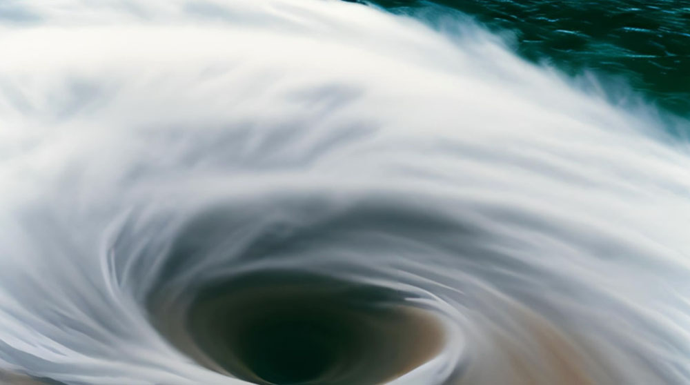
Tropical cyclone Eye
Throughout the entire area of a tropical cyclone the air currents are upward, and its entire zone is covered by dense clouds from which precipitation falls, but the eye of the storm is the small center of the hurricane, in which the sky is cloudless. This is due to the fact that there, unlike all the surrounding areas, the air drops there. The eye is surrounded by the so-called storm eye wall, which concentrates the most intense precipitation and the highest convective clouds - they can reach up to 20 km in the tropics. The maximum wind speed in tropical cyclones is noted in the ring of storm winds at a distance of about 150 km from the vortex center.
Where and when do strong tropical cyclones form?
For a hurricane to develop, in addition to warm water, a tropical cyclone needs to be on a large enough open water surface. It must originate in the central parts of the ocean, then the evaporating moisture will feed it as it progresses. If it originates near the mainland, then its trajectory will quickly enough bring it to land, and there it will weaken.
The most intense tropical cyclones form in late summer or fall, when the water is at its warmest. Strong storms such as Katrina and Sandy occur in the fall. In addition, the development of a hurricane is influenced by the synoptic situation: two tropical cyclones can be observed simultaneously, and sometimes a series of three at once. Sometimes they interact with each other, and one cyclone can be weakened by the other cyclones.
When a tropical cyclone encounters islands or archipelagos on its way, its speed decreases. The land compared to the sea is more rough, so the wind velocity decreases, and since evaporation is always lower on land than over the sea, the cyclone energy decreases as well. However, if after crossing an island, it enters the warm water surface, it may reach an even higher degree of development than before meeting the land. If the hurricane enters the mainland, there is a high probability that it will collapse. But there is another variant of development: if it enters the land north of 30-35 degrees of latitude, it can there meet a cyclone of temperate latitudes and merge with it, which, on the contrary, will lead to its strengthening.